
WHILE the Clyde is recorded as Scotland’s second longest river after the Tay, it is frequently considered to have had a greater impact on the lives of more people than any other water body in the country. This is hardly surprising given the population densities of the authority areas through which it runs in its lower reaches. There is, however, more to its influence than the merely geographical. The Clyde has had a profound effect on the national psyche and its mention still conjures up those images of strength, reliability, ingenuity, enterprise and a determination to succeed against the odds which strike a chord in the minds of many Scots.
Over the centuries, the Clyde has played a variety of roles in the history of west central Scotland from recreational playground for those who holidayed “doon the watter” or sailed the estuary to a source of power to drive various industrial mills. The challenges it has posed to those living along its banks have, at times, disguised the fact that it has never been a particularly useful river for navigation or as a routeway. For much of its early length, it travels through mostly agricultural land and while its flood plain facilitated road links both locally and as the major western route south to the English border, the river itself proved more of a handicap than an asset. The considerable number of fords and ferries which developed along the course of its tortuous journey to the sea is testament to the need to cross rather than travel along the Clyde.
The river, of course, has itself been shaped by human cultivation and habitation, as it has been dammed, dredged, drained and diverted over the centuries. The Clyde has been harnessed for the provision of fresh and clean water and the removal of waste from our homes, services we now almost take for granted. These benefits, however, have been hard won. As in other parts of Great Britain, the impact of a rapidly expanding industrial base combined with an exponential population growth during the mid nineteenth century in several towns in Clydesdale had serious implications for public health and hygiene. As the largest urban area, this was most noticeable in Glasgow itself. During the 1840s in particular, a series of major epidemics raised public awareness of the need for better housing conditions and the appropriate disposal of human waste. As was noted at the time, “dunghills lie in the vicinity of dwellings, and from the extremely defective sewerage filth of every kind constantly accumulates”.
James Pagan, avid historian of the city’s history and subsequently editor of the Glasgow Herald, highlighted the impact on the purity of the Clyde. He recorded in 1851 “we laid down just as many drains and sewers as would carry our night-soil to the nearest stream – and thus, instead of poisoning the air that we breathed, we poisoned the water that we drank. The effect of some thousands of water-closets pouring their contents into the Clyde cannot but be odious in the extreme; and every one may have felt that in summer days, after a long drought, the river, from this cause, literally sweats abomination, and we have more than once seen people sickened from it on board the steamers.”
The condition of the river was lampooned in the final verse of a popular song published in 1875. In a style somewhat akin to the poetry of William Topaz McGonagall (1825– 1902), Bonnie Banks of Clyde contains these lines:
At length we reach the city, where the Clyde runs not so clear,
And the awful smell arising makes a fellow feel quite queer,
Especially at Jamaica Bridge it would make your spirits droop,
To see the water here as thick as Cooking Depot soup.
The damage to what James Deas described as the character of the river’s salubrity from both industrial pollution and domestic waste was obvious and, despite the improvement in the provision of clean water as a result of John Frederick Bateman’s Loch Katrine scheme, improvements in sanitation, drains and the treatment of sewage only properly came into place at the end of the nineteenth century.
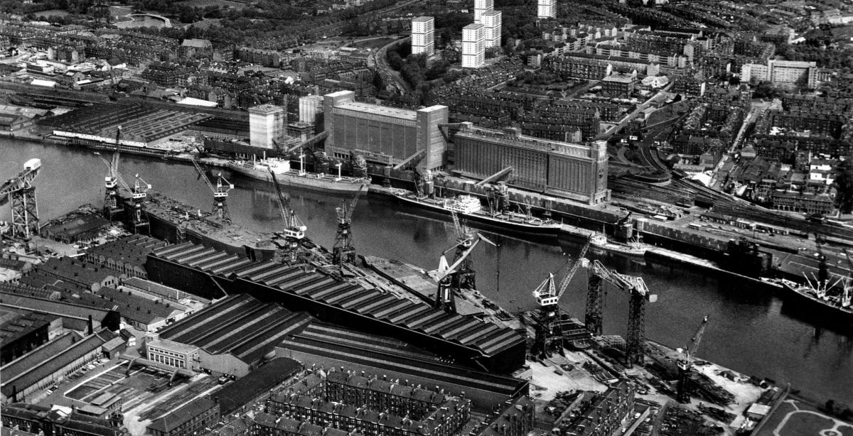
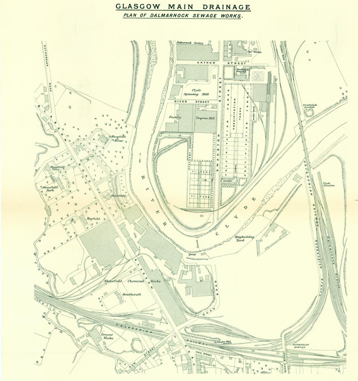
The construction of underground railway lines in the city resulted in a need to reconstruct Glasgow’s sewers and the main drainage scheme was divided into three areas, each with its own treatment works. The extensive Dalmarnock sewage works which occupies a loop enclosed by the River Clyde in southern Glasgow was mapped in detail. When opened in 1894, it was Scotland’s first large-scale site designed to deal with untreated waste and continues in operation today. In 1904, a second works was opened at Dalmuir, followed by another plant at Shieldhall in 1910.
The Dalmarnock works were designed by Gustav Alsing (1836–96), a Dane who had settled in England and who was a leading expert in chemical precipitation. He introduced several improvements in the method of disposal and was retained by the city authorities as consulting engineer. The plan was prepared by the Edinburgh cartographic firm of John Bartholomew who were contracted to provide a wide range of work for the city authorities from the late 1880s onwards. They seem to have worked closely with Alexander Beith McDonald (1847–1915), city engineer and surveyor from 1890 to 1914, and the firm’s archive has several examples of Glasgow plans covering street improvements, parks and gardens, all with McDonald’s name appended.
This depiction is no exception and dates from August 1903 when more than 2,000 copies were printed. It indicates the various precipitation tanks and filter beds of the works but also marks the effluent channel and its outflow immediately opposite Shawfield House, in addition to the various railway sidings of the Caledonian Railway where wagons were filled with solid waste for disposal. Like many other large-scale Bartholomew maps of this period, it has been based on the Ordnance Survey 6-inch map but, more importantly, it provides an image of the industrial development of the east end of Glasgow.
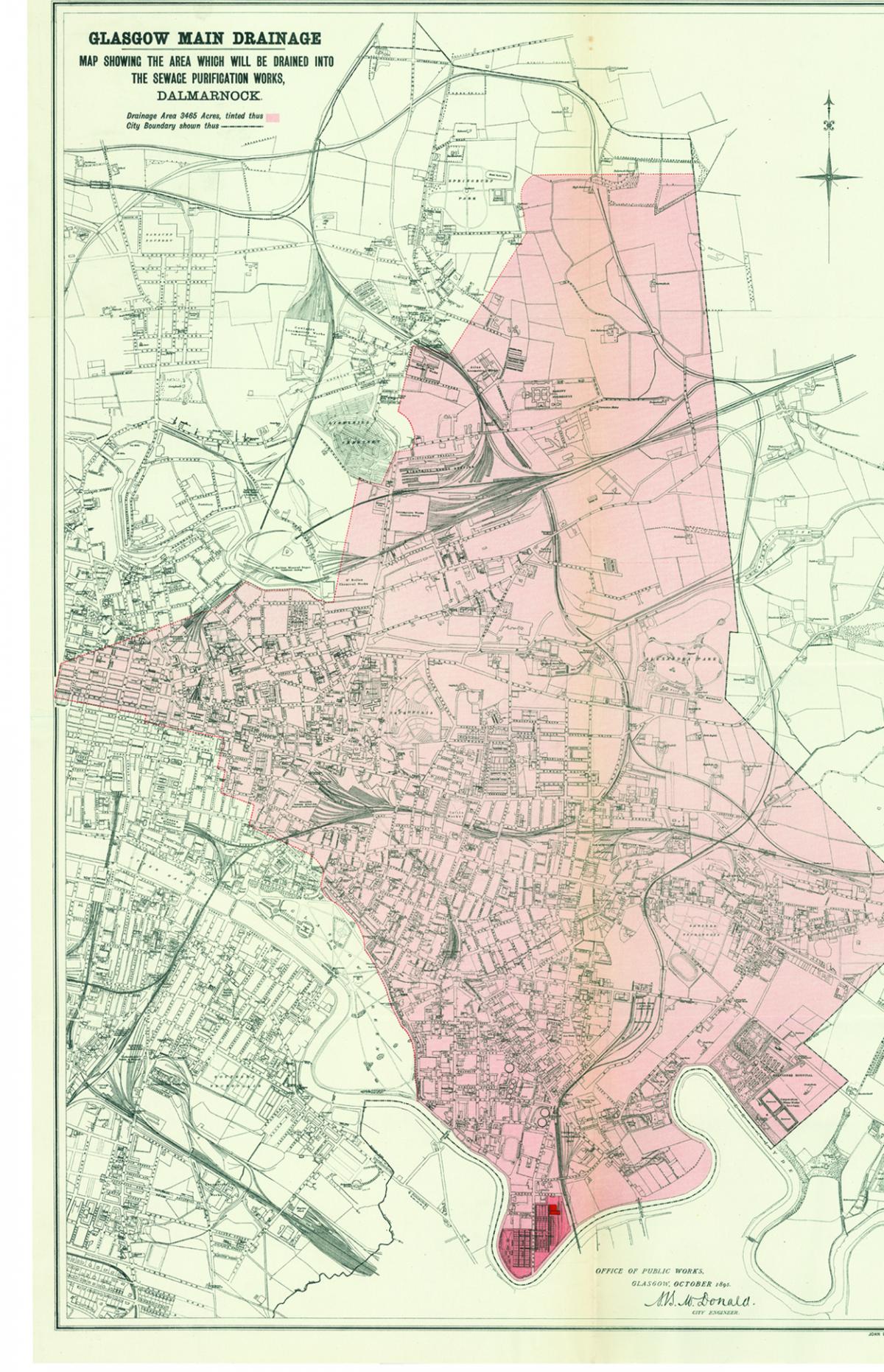
In association with the overall scheme to handle Glasgow’s waste, Bartholomew’s also prepared a general map for the city’s Office of Public Works one year after the opening of the Dalmarnock works to identify the area which would drain into its purification tanks. It highlights in light red the 3,465-acre drainage area in the east of the city, as well as the plant itself. Although this covers a considerable area, much of the land in the northern portion of the map is noticeably devoid of housing, particularly north-east of the railway engineering works at Cowlairs and St Rollox. The drainage area does extend to part of Blythswood but omits most of the city centre south of George Square and that part of the old town immediately east of Saltmarket.
The map is markedly similar in style to another document commissioned by McDonald two years later for the City Improvement Trust where various lands to be acquired for clearance were highlighted as part of the scheme to reduce overcrowding and improve the living conditions in the older part of the city. Such plans as these emphasise the growing involvement by local government in a wide range of social, health and other civic elements of urban life.
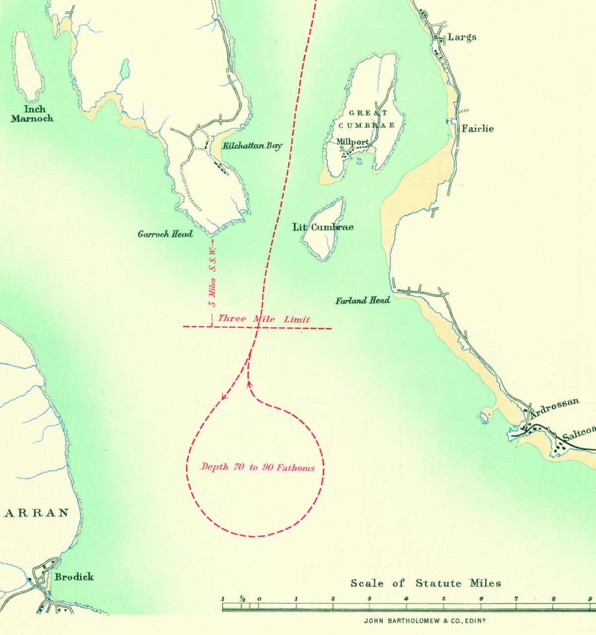
BY the use of settlement tanks at Dalmarnock, solid waste could be pressed and subsequently sold as sludge cake, marketed as agricultural fertiliser. However, not all by-products could be so utilised and, by the early twentieth century, surplus sludge was pumped into purpose-built boats which transported the material downriver on a daily basis and discharged it into the main channel of the Firth of Clyde off Garroch Head. It was only in 1998 that a European Commission Directive, designed to combat adverse effects on the environment, prevented such dumping.
The third map in this sequence shows the estuary, the route of the sludge vessel and the location in the firth where it had been designated that material could be discharged, as agreed with the Board of Trade.
Several versions of this map were produced with various dates starting in 1898. Interestingly, these earlier versions do not identify the Dalmarnock works and had very short print runs. Later printings of over 1000 copies were to be published.
As the map shows, discharge could only take place more than three miles south of Garroch Head and where the channel depth was between 70 and 90 fathoms. It also indicates the points of outfall from the three sewage works but, due to the inaccessibility of Dalmarnock, other steps had to be taken. In consequence, in 1914 a pipeline nearly 10 kilometres long was laid beneath the city’s streets to connect with Shieldhall, facilitating the pumping of untreated material there for subsequent marine disposal.
Over the twentieth century, Glasgow Corporation employed a sequence of seven vessels specifically designed to transport the waste downriver, including the Gardyloo on charter from Lothian Regional Council in the 1970s.
To more delicate constitutions, it may come as a surprise that there was a tradition of carrying organised groups of passengers on board during the summer months. Only the Shieldhall, built by Lobnitz of Renfrew in 1954, survives in British waters, now preserved and frequently used for excursions in the Solent.


Why are you making commenting on The National only available to subscribers?
We know there are thousands of National readers who want to debate, argue and go back and forth in the comments section of our stories. We’ve got the most informed readers in Scotland, asking each other the big questions about the future of our country.
Unfortunately, though, these important debates are being spoiled by a vocal minority of trolls who aren’t really interested in the issues, try to derail the conversations, register under fake names, and post vile abuse.
So that’s why we’ve decided to make the ability to comment only available to our paying subscribers. That way, all the trolls who post abuse on our website will have to pay if they want to join the debate – and risk a permanent ban from the account that they subscribe with.
The conversation will go back to what it should be about – people who care passionately about the issues, but disagree constructively on what we should do about them. Let’s get that debate started!
Callum Baird, Editor of The National
Comments: Our rules
We want our comments to be a lively and valuable part of our community - a place where readers can debate and engage with the most important local issues. The ability to comment on our stories is a privilege, not a right, however, and that privilege may be withdrawn if it is abused or misused.
Please report any comments that break our rules.
Read the rules here